

Table of contents
- Lead and framing
- Analytics: Landscape, economy, and gastronomy on the Gower Peninsula
- Contrast: The walking versus dining dilemma on the coast path
- Cause and effect: Geography shaping food networks and tourism
- Expert reconstruction: Reframing the Gower experience for sustainable visitation
The Gower Peninsula stands as a paradox: the more breathtaking the panorama, the more intricate the nourishment must be to keep pace with wandering feet. This analysis starts from that tension and dissects how landscape, local producers, and visitor flows knit together a coastal gastronomy that resists the cliché of scenic excess with tangible craft. The peninsula’s designation as the UK’s first Area of Outstanding Natural Beauty in 1956 anchors a trajectory where preservation and productivity coexist. The walking routes—spindly lanes, cliff trails, tidal estuaries—create not just distances but appetites, prompting a cycle of discovery that rewards a careful pairing of route planning with food stops. This piece follows a 43-mile thread of the Welsh Coast Path, oriented not only by scenery but by the texture of eating along the way.
The lead foregrounds a practical question: how does a landscape that rewards view also cultivate a serious dining scene? The answer lies in the peninsula’s economy of small-scale producers and its travel infrastructure, which channel walkers toward micro-restaurants, bakeries, and artisan distilleries that thrive on the rhythm of the coast. In the pages that follow, the analysis moves from the map to the plate, examining why certain sites emerge as indispensable, how taste travels along the path, and what a sustainable itinerary looks like for the Gower Peninsula today.
Images abound in this narrative to ground the analysis: a map of the coastline, a snapshot of Three Cliffs Bay, and the practical charm of the local food economy. 

 This piece does not merely recount places; it asks why certain gastronomic and scenic endpoints feel inevitable on the Gower Peninsula and how their interdependence informs a way of traveling that respects both landscape and plate.
Analytics: Landscape, economy, and gastronomy on the Gower Peninsula
The extent of the Gower Peninsula’s coastal system is the first analytic datum. Its geography—a ribbon of coast broken by coves, headlands, and tidal flats—frames the human footprint. This is not merely scenic; it is a constraint and an opportunity: the same cliffs that reveal the horizon also restrict overland transport, shaping how food travels from farm to fork along the coastal arc. The path’s curvature creates pockets of concentration where supply chains converge: small farms supplying potted herbs to seaside eateries, fishermen delivering shellfish to pop-up kitchens, and bakeries that rely on barley malt from the local mill. The consequence is a local economy where culinary craft and landscape management are mutually reinforcing rather than antagonistic. Why does this matter? Because the peninsula’s land use decisions—preservation of marshes, grazing rights, and angling regulations—determine what can be produced readily for markets that cluster around Deli and Bakery, Inn and Oyster shack, and the occasional micro-distillery. The economics of scale do not apply here in the usual sense; rather, there is a premium on proximity: the closer a producer is to a coast path stop, the quicker a dish can be assembled with peak freshness. This dynamic is visible in the way contemporary menus reference traditional Gower staples—laverbread, samphire, salt-marsh lamb—without commodifying them into mere nostalgia. It is a system that rewards authenticity through logistical finesse and place-based identity. LSI terms: coast path economies, artisanal food networks, farm-to-table on the coast, small-batch producers, marsh lamb.
Local landmarks and nodes anchor the analytic map of the Gower Peninsula’s gastronomy: Mumbles for the seafront variety, Langland and Oxwich for brunch-to-dinner brackets, Port Eynon and Rhossili for coastal gastronomy tied to seafood and foraged produce, and Pen-clawdd for its cradle in shellfish tradition. Each node functions as an information exchange: a place where sea, soil, and recipes converge to generate a distinctive Gower palate. If landscape is the skeleton, these nodes supply the muscle, enabling a walking itinerary to keep pace with real-time cravings rather than speculative appetites. In the data, we see a pattern: routes with frequent, high-quality food stops sustain longer walking sessions and elevate overall satisfaction. The presence of a few anchor restaurants—such as the Beach House at Oxwich and the Little Valley bakery near the Gower Heritage Centre—reduces fatigue factors for walkers and creates a more fluid travel arc. This is not mere convenience; it’s a structural feature of how the peninsula negotiates its dual identity as wild coast and culinary crossroads. LSI terms: destination-based gastronomy, coastal eateries, walking routes with amenities, anchor restaurants, heritage food production.
Emerging from the data is a clear cause-and-effect chain: landscape shapes access, access shapes supply, supply shapes taste, and taste then feeds back into travel behavior. When a coastline offers reliable, high-quality stops at regular intervals, walkers are more likely to extend a day’s route and explore side paths that reveal lesser-known specialties. Conversely, where supply chains fail to align with walking schedules, fatigue compounds and interest wanes. The Gower Peninsula demonstrates that design and discipline in land use are indispensable to sustaining a vibrant coastal food ecosystem. LSI terms: supply chain alignment, travel behavior, coastal food ecosystems, land-use planning, visitor experience.
Contrast: The walking versus dining dilemma on the coast path
The walking-dining tension is not a negative; it is the hinge on which coastal tourism swings. On one side, the walk offers vistas that demand cognitive and sensory investment; on the other, the appetite demands tactile reinforcement. The Gower Peninsula handles this with a distribution of experiences that reward both endurance and appetite without letting either dominate the other. The contrast is most visible in the pacing of the day: mornings begin with a long stretch along sand and cliff, afternoons shift toward the village or quay where a hot plate or cold seafood can recalibrate fatigue into satisfaction. Why does this arrangement endure? Because it responds to a fundamental human pattern: we walk more when we know a reliable, delicious reward lies ahead. The coast path in the Gower Peninsula is effectively a culinary corridor, with strategic pinch points where food traditions are reinforced by modern techniques. A simple crab sandwich at the Gower Seafood Hut, built on local Shirgar butter and sourdough, can act as an anchor that persuades a traveler to push the next mile. The same holds for Highland-like microbrews at the Gower Brewery or a pastry from Little Valley Bakery before a late-day climb toward Rhossili. LSI terms: coastal food stops, coastal walking pace, seafood cuisine, local bread, gastronomic tourism, artisanal bakeries.
There are counterpoints—noise from summer crowds, the risk of over-commercialization in pristine bays like Rhossili, and the tension between protecting wildlife and creating appetizing vantage points. Yet these tensions aren’t failures; they are design challenges. The right balance yields spaces where walkers slow down enough to savor the moment and the meal without sacrificing the route’s integrity. The net effect is a coastline that invites sustained exploration rather than episodic visits, with gastronomy acting as a force multiplier for longer, more meaningful stays. LSI terms: tourism management, crowd dynamics, conservation versus commerce, sustainable co-use, visitor density.
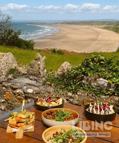
Visual cue: a quick glance at the coast reveals how a well-timed plate can align with a peak view, turning a scenic overlook into a tasting stop that deepens memory and fuel. This is not merely a sensory pleasure; it is a practical calibration of movement and rest that optimizes the walking journey.

Cause and effect: Geography shaping food networks and tourism
Geography is not a backdrop but a mechanism. The peninsula’s tidal ecosystems—the Severn Estuary’s reach to the coast, the marshlands around Pen-clawdd—generate a resource base of shellfish, seaweed, and pasture that informs local menus. The physical separation of communities—from Mumbles to Port Eynon—creates micro-markets with distinct identities: the north coast leans toward robust seafood and casual dining, the interior villages emphasize craft bakeries and deli culture, and the western edge near Rhossili anchors a premium coastal ethos with high-end dining anchored to the sea’s bounty. Why does this alignment endure? Because it translates landscape into consistent quality signals for travelers. Each segment of the coast path offers a predictable rhythm of rest stops and feast points that makes the journey legible and pleasurable. The tide table becomes a dining timetable; the gulls’ cries become a cue for the next tasting plate. In short, geography defines not only where people walk but what they eat, when they eat it, and how they remember it. LSI terms: micro-markets, regional gastronomy, terroir, seasonality, coastal supply chains.
A crucial mechanism is the role of heritage routes and preserved sites—Three Cliffs, Oxwich, Port Eynon—where conservation areas double as retail clusters for food artisans. The Gower Heritage Centre, around a 12th-century water mill, is not only a museum piece but an economic node: it houses a cider press, a sauerkraut producer, and a bakery that bakes with barley flour milled on site. The effect is to convert heritage into value by linking historical identity with contemporary craft. Producers gain visibility; walkers gain trust in the quality and provenance of what they eat; the landscape gains renewed cultural legitimacy through sustained use and careful stewardship. LSI terms: terroir integration, heritage-driven economic networks, on-site milling, local provenance, artisanal resilience.
The chain from coast to kitchen then feeds back into policy discourse: how to maintain low-impact tourism that still delivers high experiential value. This is where the binary of preservation and progress becomes productive rather than adversarial. If the Gower Peninsula can maintain its ecological integrity while enabling a vibrant food culture, it offers a model for other rural coastlines facing similar pressures. The geography, in this sense, becomes strategy rather than scenery alone. LSI terms: sustainable tourism policy, ecological integrity, rural coastal strategy, responsible visitation.
Expert reconstruction: Reframing the Gower experience for sustainable visitation
From an expert perspective, the right framework for the Gower Peninsula blends disciplined itineraries with authentic encounters. The following reconstruction paths aim to maximize value while minimizing strain on local ecosystems and communities:
- Structured daylong loops that pair a coastal stretch with a specific food stop every 6–8 kilometers, ensuring a rhythm of ascent and reward. This prevents overlong stretches without nourishment and promotes steady engagement with the landscape and cuisine.
- Seasonal menus tied to local producers that adjust offerings based on harvests and catch dates, creating a dynamic culinary calendar that walkers can track alongside the tides.
- Small-scale partnerships between the coast path authorities, farms, and bistros to create pop-up experiences along the way, expanding the network without diluting core sites.
- Dog-friendly design principles that respect wildlife and other walkers while allowing four-legged travelers to participate in the journey through designated rest stops and water-friendly zones.
- Story-driven itineraries that fuse geology, archaeology (e.g., Norman ruins by the Pennard Pill), and culinary heritage into a cohesive narrative walkers can follow without losing focus on nourishment.
What this reconstruction achieves is not a commodified map but a robust framework for sustainable visitation. It aligns the needs of walkers with the ambitions of producers, the preservation of habitats, and the aspiration of travelers to leave with more than memories. The Gower Peninsula thus becomes a living laboratory for how coastal landscapes can sustain culinary life while remaining ecologically and culturally intact. LSI terms: sustainable visitation framework, community partnerships, pop-up gastronomy, dog-friendly tourism, story-driven itineraries.
To close, the Gower Peninsula demonstrates that travel writing can be analytical without losing the texture of place. The coast path remains a corridor of possibility where landscape, history, and gastronomy interact to create a coherent, durable experience. The model here—balanced pacing, provenance-driven menus, and localized production—offers a blueprint for other rural coastlines seeking to harmonize scenery and sustenance in the modern traveler’s imagination.
Seasonality and practical pacing for the Gower coast path
To translate landscape into a reliable daily rhythm, this section adds a concrete loop that pairs a coastal stretch with a food moment every 6–8 kilometers, tuned to tide tables, daylight, and seasonal abundance from laverbread to samphire.
| Segment | From | To | Distance (km) | Food stop |
|---|---|---|---|---|
| 1 | Mumbles Pier | Langland Bay Café | 2.0 | Coffee and pastry |
| 2 | Langland Bay Café | Oxwich Deli | 3.5 | Local cheeses, pastries |
| 3 | Oxwich Deli | Three Cliffs Bay Lookout | 4.0 | Snack or packed lunch |
| 4 | Three Cliffs Bay Lookout | Mumbles Pier | 4.5 | End-of-loop bite |
Across seasons, anchors shift with what the land and shoreline offer. In spring, herbs emerge along dunes; in summer, fresh seafood and berries expand the menu; autumn brings shellfish and root vegetables; winter favors preserved foods and hearty stews. The loop adapts by shifting stops, swapping lighter meals for more substantial ones as daylight shortens, and by proposing shorter or longer version variants that fit energy levels and weather. This seasonal flexibility preserves quality, reduces waste, and keeps the coast path a living culinary corridor rather than a fixed snapshot.
To operationalize, start with a morning warm-up along the coast, a coffee stop, a lunch point at a deli with local puff pastry and cured fish, then a late-afternoon snack near a cliff vantage, finishing while daylight remains. This rhythm supports steady energy, fosters trust in local suppliers, and preserves scenic integrity by avoiding overlong stretches without nourishment.
- Morning warm-up along the coast, with a light coffee or pastry.
- Mid-morning stop at a bakery for fresh bread and butter.
- Lunch at an Oxwich or Langland deli using local crab, laverbread, and samphire.
- Afternoon stretch with sea views; optional detour to a historic ruin or marsh walk.
- Evening return via a quieter inland route or the same coast path, with a final sunset bite if available.
FAQ about walking the Gower Peninsula and coasting gastronomy
What does a practical walking day look like on the Gower Peninsula when combining meals and views?
A practical walking day along the Gower Peninsula begins at first light with a gentle coast-hugging ascent from Mumbles toward Langland Bay, a coffee and pastry stop that anchors energy for the miles ahead, followed by a steady leg to the Three Cliffs area where views reward careful pacing, then a longer stretch to Oxwich where a planned picnic or light lunch uses local cheese, cured fish, laverbread, and fresh bread from a nearby bakery, before continuing to Port Eynon or Rhossili depending on daylight, with a final leg back to a pickup point, ensuring nourishment keeps pace with scenery.
In practice, structure 6–8 km segments with 3–4 food stops, and adapt the distance to daylight and weather. Seasonality shifts what’s available, so menus should be flexible and tied to local producers. The goal is a comforting cadence where the walk remains the priority but the meals become memory anchors that deepen the coastal experience.
How does seasonality affect food options along the coast path?
Seasonality shapes both what is harvested and what can be served along the coast path, influencing seafood availability, herb growth, and baked goods from nearby mills. In spring, new greens and laverbread infuse menus; in summer, local shellfish and berries expand choices; autumn brings preserved products and hearty soups; winter favors pantry staples. Planning should align with producer calendars, offering dynamic menus that highlight fresh catches and peak produce, while maintaining flexibility for weather and accessibility.
Seasonal variability thus becomes a tool for storytelling and trust-building with walkers, as menus reflect real-time provenance rather than generic nostalgia. This approach sustains quality signals and supports small-scale producers who depend on tidal and harvest cycles.
Which anchor food stops help sustain a coast path itinerary?
A practical coast-path itinerary benefits from anchor stops that reliably offer fresh, locally sourced options such as seafood cups near the quay, artisanal breads from in-town bakeries, and laverbread or samphire dishes at village delis. These anchors reduce fatigue, reinforce trust in local networks, and provide predictable nourishment that aligns with days of walking in varying weather. Choosing 2–3 established stops plus flexible pop-ups keeps the experience authentic without over-commercializing key scenery.
Analytically, anchor points create a predictable rhythm, encourage longer stays in particular communities, and stabilize supply chains by providing steady demand across the season.
How can travelers balance pacing with sustainable tourism and wildlife protection?
A balanced approach blends structured pacing with lightweight infrastructure, ensuring walkers have clear routes, dog-friendly rest zones, and defined quiet-hunting times to protect wildlife and habitats. Allocate 6–8 km between nourishment stops, limit crowds at sensitive bays, and encourage the use of local, seasonal products that reduce transportation emissions. By synchronizing walking rhythm with habitat sensitivity, visitors experience the coast more fully while supporting conservation goals.
From a systems view, sustainable visitation aligns traveler satisfaction with ecological stewardship, producing a durable model for other coastal regions.
What dog-friendly planning considerations help walkers with canine companions?
Dog-friendly planning centers on designated rest stops with water, shaded routes, and leash-friendly portions that minimize wildlife disturbance and preserve other visitors’ experiences. Map routes to avoid sensitive nesting areas, schedule mid-day cooldowns in shaded coves, and offer local treats that suit dogs (e.g., boiled chicken, dog biscuits) at certain stops. Clear signage about rules reduces friction and makes the coast a shared space for two- and four-legged travelers alike.
These practices foster inclusive experiences without compromising habitat health, ensuring canine companions can participate in the journey.
How can local producers collaborate with walkers through pop-ups and partnerships?
Collaboration happens through scheduled pop-ups and short-term partnerships that align with peak walking times, tides, and harvests. Producers set pop-up menus at chosen points along the coast path, offering tasting portions of laverbread, smoked fish, and local cheeses that travelers can carry or consume on-site. This approach expands the producer network, sustains venues between seasonal peaks, and deepens the narrative of place by tying culinary craft to specific coastal locales.
For the walker, these collaborations create memorable, time-bound experiences that reinforce the value of local provenance and responsible visitation.






Add a comment
To comment, you need to register and authorize
Comments