

European Hiking Trails: Depth, Diversity, and Design of a Continent-Scale Trekking Network
Table of contents
- Lead
- Analytics-driven view of European hiking trails
- Contrasting iconic routes: coastlines to alpine passes
- Cause and effect: infrastructure, accessibility, and experience
- Expert reconstruction: designing sustainable European itineraries
- Conclusion
Lead
If you have a head for heights, European hiking trails offer more than scenery; they are a lens on how a continent designs access, sustains remote landscapes, and choreographs human movement. These paths range from cliff-edge coastal treks to high-alpine traverses, weaving together cultural heritage with ecological constraints. The main question is not merely where to walk, but how to walk in a way that preserves solitude, safety, and the very landscapes that make the routes so compelling. The stakes are real: overcrowding on famed segments can erode experience and degrade fragile environments; poor planning can turn a pristine ridge walk into fatigue and risk. Yet when done right, a continent-scale network promises depth—elevation profiles, seasonal windows, hut-to-hut logistics, and a rhythm that respects both nature and communities. This analysis maps depth, contrasts experiences, and proposes a framework to plan sustainable itineraries across Europe while acknowledging the friction between accessibility and wilderness.
The essence of European hiking trails lies in the balance between scale and detail: long-distance routes stitched across regions and the granular decisions that ensure a safe, meaningful walk. In practice, depth emerges from four pillars: terrain and elevation, infrastructure and transport links, seasonality and weather, and the social economy around huts, refuges, and local guidance. The journey from Amalfi’s Sentiero degli Dei to the pine-scented uplands of Kungsleden, or from Spain’s Ruta del Cares to Portugal’s Ponta da Piedade–Praia da Luz coast, tests this balance. The analysis that follows dissects these pillars, reveals how they shape experience, and outlines a method to design itineraries that honor both landscape integrity and traveler aspiration while avoiding common pitfalls of mass tourism and ecological strain.
Analytics-driven view of European hiking trails
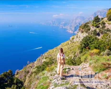
The analytic lens starts with a simple premise: depth in hiking trails appears where there is a meaningful convergence of geography, accessibility, and infrastructure. European hiking trails are not monolithic; they differ in elevation gain, surface quality, and the density of waypoints that enable longer, safer journeys. The Sentiero degli Dei, for example, is a 10-kilometer ascent that rewards with panoramic views to Capri, but its value is amplified by the hillside topology that magnifies elevation change in a short span. The corridor’s popularity is not incidental; hikers can combine a coastal vantage with practical access by bus and ferry, smoothing the logistics without compromising the vertical drama.
In a more data-driven sense, depth accrues where trail networks interlock with public transport and shelter systems. The Five Lakes hike in the Tatras integrates a steep ascent with a cluster of alpine huts and a natural amphitheatre that frames the lake panorama. The hut network is not mere accommodation; it is a safety and pacing mechanism, dictating daily distances, stopover strategies, and weather contingency plans. Likewise, routes such as the Ponale Path leverage historic tunnels and cliffside views to convert a regional walk into a memorable ascent with a clear, cumulative elevation profile. Depth, then, is a product of topography, sheltering infrastructure, and access that reduces friction for multi-day itineraries.
A robust metric system for European hiking trails blends elevation gain, distance, surface type, shelter density, and transport integration. The Kungsleden segment Abisko to Nikkaluokta illustrates how remoteness can be mitigated by hut systems and seasonal accessibility windows. Conversely, high-traffic coastal routes tend to accumulate variability in surface wear and crowd density, which affects pace and safety. The analytics reveal not just where trails are deep, but why certain corridors sustain longer, more reflective journeys while others collapse into crowded, high-velocity waves of hikers. The implication for planners is clear: depth should be measured not only in kilometers and meters climbed, but in the quality of transition between stages and the resilience of the supporting ecosystem.
Finally, data-informed comparison across routes emphasizes the critical role of governance and funding in sustaining depth. The transport flexibility provided by combined bus and ferry tickets, for instance, reduces the cognitive load of planning and preserves the emotional arc of the trek. When public transport integration is reliable, hikers can choose longer routes with flexible pacing; when it is fragile, routes lose depth as walkers become locked into shorter segments or forced returns. The result is a structural insight: depth in European hiking trails is inseparable from governance, infrastructure, and the social economy around huts, refuges, and local operators.
Contrasting iconic routes: coastlines to alpine passes
Contrasting routes reveal how geography frames experience, audience, and risk. The Sentiero degli Dei presents a vertiginous hillside panorama punctuated by Mediterranean light, while the Kungsleden unveils Arctic quiet along snow-dusted ridges. The Ruta del Cares carves through a deep canyon with a narrow, engineered feel, whereas the Ponale Path blends cliffside drama with historical tunnels and a gentle return through a lakeside valley. Each route illustrates different audience expectations and constraints around safety, pacing, and social interaction.
The coastal-to-alpine spectrum also highlights crowd dynamics. Coastal paths often draw seasonal crowds because access points are close to urban hubs and public transport is frequent, which can create social friction on popular segments. Alpine and Arctic routes, by contrast, may spread hikers over longer durations because huts are spaced farther apart and weather windows are narrower. The consequence is a difference in planning: coastal hikes reward early starts and day-to-day flexibility, while alpine and Arctic treks demand accurate weather forecasting, fixed day-by-day pacing, and contingency options for adverse conditions. In other words, the geography dictates the tempo and the social fabric of the journey.
A practical comparison emerges when we map route archetypes to traveler intent. Family-friendly coastal trails reward accessibility and scenery with moderate elevation profiles and frequent amenities. Remote hinterland routes emphasize solitude, longer distances between refuges, and self-reliant trekking skills. Cultural-historical routes—like those through Spain’s Picos de Europa or Portugal’s Algarve coastline—combine natural drama with legibility of the path, clear signposting, and the opportunity to weave in local gastronomy and craft heritage. The diversity across icons is not a hurdle; it is a strength that invites different audiences to experience European hiking trails through distinct lenses of risk, immersion, and reward.
Cause and effect: infrastructure, accessibility, and experience
Infrastructure is not a backdrop; it is a primary driver of what hikers experience and how the landscape is perceived. The availability of huts or refuges creates an expectation of multi-day itineraries with predictable stops, which, in turn, influences route selection, pacing, and risk management. The universal presence of signposting and waymarked trails gives hikers confidence to navigate unfamiliar terrain, reducing cognitive load and enabling longer, deeper treks. When infrastructure aligns with terrain, the experience feels seamless: you step onto a path, trust the wayfinding, rest at a hut, and resume with renewed energy.
Public transport integration is a pivotal factor in the European hiking experience. The combined bus-and-ferry ticket offered by Travelmar for the Amalfi trek is a prime example of how mobility systems extend reach, shorten access times, and create a continuous experiential arc. This kind of integration reduces the need to own multiple regional passes and lowers the friction that previously deterred longer journeys. Conversely, gaps in transport connectivity may compel hikers to shorten itineraries, increase the hazard of weather exposure, or miss out on scenic linkages that define a route’s character. The causal chain is straightforward: transport reliability feeds route confidence, which sustains longer, more meaningful treks.
Seasonality and weather are the natural levers in this causal framework. The same path can feel world apart depending on wind, rain, or temperature. Hut availability, practical gear choices, and day-by-day pacing hinge on reliable forecasts and shoulder-season timing. The Five Lakes hike in the Tatras demonstrates how elevation and exposure create seasonal windows that demand careful planning around hut occupancy and meal services. In contrast, a coastal path with milder microclimates may permit a longer daily distance with easier weather margins, shaping not only how far you walk but how deeply you experience the surrounding ecosystem and culture.
Economic and governance structures underpin the sustainability of these dynamics. Community-run huts, local guides, and regional transport subsidies help maintain trail networks and preserve the character of the hike. When policies emphasize conservation and visitor education, the trails retain their ecological integrity and cultural authenticity, allowing future hikers to encounter the same landscapes year after year. The causal insight is that responsible stewardship is as essential to depth as physical terrain; without it, even the most dramatic ridge walk can degrade into a managed spectacle with diminished sensory payoff.
Expert reconstruction: designing sustainable European itineraries
If you were to reconstruct a practical, sustainable framework for European hiking trails, you would start with a core set of principles: preserve solitude, prioritize safety, respect landscapes, and optimize infrastructure without eroding authenticity. The reconstruction below translates those principles into actionable steps for planners, guides, and hikers who aim to craft itineraries that maximize depth while minimizing ecological footprint.
- Assess terrain and elevation in advance: map cumulative gain, exposure risk, and probable surface conditions; align daily distances with terrain difficulty to maintain a consistent tempo without overburdening participants.
- Leverage hut networks and refuges: design itineraries around reliable sheltering options, ensuring redundancy during peak seasons and flexibility during shoulder periods. Hut-based pacing reduces gear load and encourages social interaction among travelers while maintaining safety margins.
- Integrate transport smartly: choose routes with robust public transport links to minimize car dependence, enable staggered starts, and provide contingency access for weather disruptions. Consider multi-modal options (bus, ferry, rail) to extend possible itineraries without adding complexity.
- Embed seasonal timing and weather contingency: build in flexible windows for each segment, with alternative legs if storms or heat waves constrain access. Weather-aware planning preserves trail conditions and reduces erosion caused by forced detours.
- Prioritize ecological stewardship: implement waste management, leave-no-trace practices, and education on local biodiversity. Ensure that signage, trail work, and shelter maintenance reflect local ecological constraints and cultural heritage.
- Factor social experience and safety: balance solitude with social opportunities through staggered itineraries, guided options for unfamiliar terrain, and clear safety protocols. Training on navigation, first aid, and risk management should be accessible to all participants.
A practical blueprint emerges when you map a route from a well-known hub to a lesser-known corridor, ensuring you don’t overwhelm a single node with visitors. For example, a European hiking itinerary could begin with a coastal-to-inland sequence along a proven coastal path, then shift to a high-altitude traverse that relies on a series of huts and reliable transport connections to break days into manageable segments. This approach preserves the sense of discovery—gradual exposure to elevation gain, new habitats, and regional cuisines—while maintaining practical safety margins and minimizing ecological impact.
The expert reconstruction also recognizes that data-informed decision-making must be paired with cultural sensitivity. Local guides and conservation groups should be involved in route design to ensure that a hike supports regional economies and respects protected areas. By treating trails as living systems rather than fixed spectacles, planners can sustain the depth that defines European hiking trails for current and future hikers alike. Ultimately, the goal is a portfolio of itineraries that invites diverse audiences to experience Europe’s landscapes through responsibly managed, high-signal pathways that preserve both solitude and spectacle.
Conclusion
European hiking trails offer a unique combination of depth, variety, and practical accessibility. The best itineraries balance elevation, shelter availability, transport integration, and seasonal timing to deliver extended, meaningful journeys without sacrificing safety or ecological integrity. Through analytics, contrasts, causal understanding, and expert planning, hikers can craft experiences that honor the landscape and the communities that sustain it. The future of European trekking lies in systems thinking: design routes that respect terrain, connect people with place, and preserve the very drama that drew travelers to these trails in the first place.
Practical planning for diverse hikers
Hikers vary in goals, pace, and accessibility needs. A critical gap in the current material is translating depth metrics into actionable itineraries for families, solo trekkers, and travelers with mobility considerations. The following compact framework turns landscape depth into practical, safe routes that respect ecosystems and local communities.
| Segment | Elevation gain (m) | Distance (km) | Shelter density | Transport links | Profile fit |
|---|---|---|---|---|---|
| Sentiero degli Dei (Amalfi Coast) | 350 | 10 | 4 | 5 | All levels; day hike variant |
| Kungsleden (Abisko–Nikkaluokta) | 700 | 40 | 6 | 3 | Hut-based, multi-day |
| Five Lakes Trek (Tatras) | 520 | 12 | 5 | 4 | Accessible hut network |
| Ruta del Cares (Spain) | 180 | 24 | 3 | 3 | Coastal–canyon day hike |
Table 1 translates terrain and shelter access into daily planning heuristics. Use it to align daily goals with shelter availability and transit options, enabling predictable pacing for families or flexible threading for solo trekkers. This approach preserves depth while reducing fatigue and logistical friction.
Hut coverage: 1 every 6–9 km
Transport integration: high
This visual condenses depth into three actionable levers: terrain intensity, shelter density, and mobility links. When all three align, multi-day treks sustain tempo and safety without turning into logistical scrimmage. Use these signals to select corridors that match your group’s capability and preferred pace, especially during narrow weather windows or shoulder seasons.
- Family coastal route: 4–5 days along a cliffside path with frequent ferry or bus connections; daily distances 8–12 km; accommodation in coastal guesthouses; focus on safety and scenery.
- Solo alpine traverse: hut-to-hut progression with weather contingency; shorter daily legs (12–20 km) to allow time for navigation and acclimatization; consider guided options for navigation and safety.
- Mobility-conscious itinerary: flatter coastal segments with well-signed, accessible surfaces and transport access to rest points; prioritize frequent rest opportunities and adaptive pacing.
By plotting depth through these profiles, planners can craft multi-day trekking experiences that respect both landscape integrity and participant wellbeing. The aim is to expand participation while maintaining high-signal routes that highlight seasonality, local culture, and ecological stewardship.
FAQ about European hiking depth and planning
How can travelers design deep European itineraries for different profiles?
travelers design deep European itineraries by pairing terrain complexity with shelter availability and transport links to create balanced daily goals. This alignment supports families seeking safety and scenic variety, solo trekkers chasing solitude, and mobility-conscious hikers who need accessible paths. The core idea is to map elevation and distance against hut density and transit options, then add flexible day-by-day contingencies to accommodate weather or crowd dynamics. Practically, start with a hub-to-hub concept, then layer hut networks and transport anchors to widen the window of feasible pacing. This approach enables multi-day trekking with depth preserved across changing conditions.
In practice, you’ll use a simple framework: pick a hub, select adjacent segments with reliable shelter, verify bus/ferry connections, and plan two contingency days. Repeat with variations to tailor the route to family needs, solo ambitions, or accessibility requirements. The result is a scalable method that keeps depth intact while expanding participation and safety margins.
Which infrastructure most enhances depth on multi-day routes?
For depth, a robust hut or refuge network, clear wayfinding, and predictable transport links are critical. These elements reduce cognitive load, enable longer journeys without repeated gear checks, and foster social interaction that enriches the experience. The combination of reliable shelters, signposted trails, and flexible transit options creates a steady rhythm that sustains engagement across multiple days and diverse weather windows. Practically, route design should center on hut spacing that supports 15–25 km daily legs and on transport tickets that link alternative start points seamlessly.
How does transport integration influence itinerary depth?
Transport integration expands options and reduces planning friction. When buses, ferries, and trains connect trailheads, hikers can vary daily distances, skip unfavorable segments, or re-route in response to weather or crowding. This flexibility preserves depth by maintaining momentum and reducing the risk of detours that erode the overall arc. A practical rule is to anchor each segment to at least one reliable transit link and one shelter; then add contingency days that leverage off-peak services to keep crowds from concentrating on a single node.
What safety considerations accompany hut-to-hut trekking?
Safety hinges on weather awareness, navigation capability, and defined safety protocols. Hut-to-hut trekking benefits from pre-trip briefings, emergency communication plans, and well-marked trails. Huts provide social opportunities and rest points, but planners should include clear signposting, seasonal occupancy forecasts, and weather contingency options. Training in navigation, first aid, and risk assessment should be accessible to all participants, with gear lists and contingency budgeting that reflect local conditions and seasonality.
How can hikers avoid overcrowding on popular trails?
To avoid crowding, diversify route choices across seasons, pair popular segments with lesser-known alternates, and use staggered start times. Public transport-friendly itineraries enable flexible pacing, reducing peak-day congestion. Encouraging small-group or guided options off the main tracks helps sustain depth in crowded corridors while distributing economic benefits to more communities. A key tactic is to design a suite of linked itineraries that share logistics but differ in scenery, so travelers can rotate through lighter, less-busy paths while maintaining a core experience of depth and landscape appreciation.





Add a comment
To comment, you need to register and authorize
Comments
A productive line of inquiry is the balance between accessibility and wilderness. Opening more routes to a broader audience can democratize the experience but may also intensify pressure on fragile habitats, cultural sites, and local services. Conversely, routes with dense technical challenges or sparse infrastructure risks becoming exclusive preserves for specialists. The article’s data‑driven framing offers a practical lens for planners, but it must be complemented by conversations about who is being served, how information reaches diverse hikers, and how local economies are genuinely supported rather than displaced. Depth, in this sense, is a social as much as a geographical property: it depends on safety nets, clear wayfinding, and a welcoming guiding culture that invites support as well as independence. Thinking forward, how can governance models align conservation with opportunity so that subsidies, maintenance, and education sustain both the landscape and the communities that depend on it? In short, depth on European trails is a shared project requiring listening to landscapes, users, and local knowledge, then translating that listening into inclusive policies, sustainable funding, and on‑the‑ground design choices that endure.