

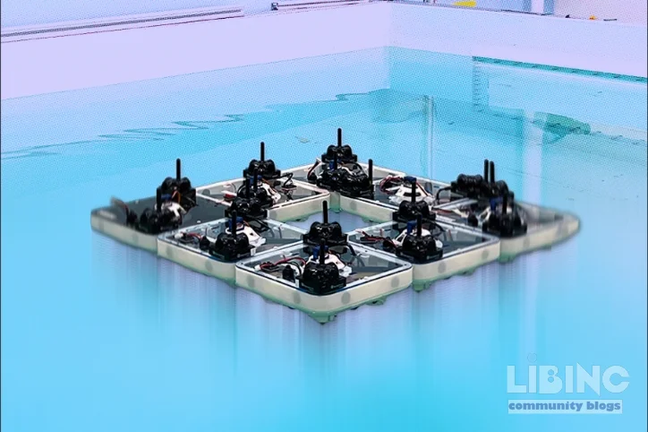
FloatForm: A swarm of autonomous boats turning water into a programmable infrastructure
Table of contents
The waterfront is often imagined as the city's edge, a fixed boundary between land and water. In practice, it behaves as a dynamic interface where movement, activity, and risk converge. FloatForm reframes this boundary: a swarm of small, square boats that can join into larger, functional structures on demand, dissolve, and reconfigure, with little direct intervention. The concept translates the idea of programmable space from buildings to water. This is not a single machine but a distributed system where autonomy, coordination, and physical design align to create adaptable infrastructure. The work compels urbanists and engineers to rethink how cities deploy space, respond to crises, and design for mobility on the water. The lead conclusion is simple: if you can orchestrate dozens of autonomous vessels locally, you unlock a scalable, resilient, waterborne layer of the city. FloatForm embodies that shift, turning water surfaces into programmable assets rather than perpetual constraints.
In this exploration, we probe the FloatForm architecture, its performance in laboratory tanks, the friction points that scale from eight boats to larger swarms, and the broader implications for urban design. We examine why a distributed approach matters in practice, what tradeoffs emerge when you minimize central planning, and how real-world disturbances test the limits of a waterborne, self-assembling system. The analysis blends engineering insight with urban theory to explain not just what FloatForm does, but why its design choices matter for city life and emergency response. The core question is whether modular, autonomous vessels can reliably form and reconfigure infrastructure on water and, crucially, what it would take for such a system to operate in real canals and harbors. The answer lies in the interaction of hardware, control logic, and environmental reality, all grounded in the FloatForm experiments and their implications for future waterfronts.
In the end, FloatForm proposes a new form of urban elasticity: water becomes a mutable surface that expands, contracts, or reconfigures as needed. Yet this vision carries hidden conflicts—between centralized oversight and distributed autonomy, between energy budgets and continuous motion, between laboratory success and canal-scale robustness. The direction of analysis here is to debunk assumptions that scale linearly, assess the resilience of local rules under real-world disturbances, and project how a swarming, autonomous, lake- or canal-based infrastructure could reshape mobility, emergency response, and public space. The argument follows a clear throughline: decoupling computation from any single agent, while preserving a coordinated target shape, yields scalable, robust outcomes that current, centralized planning struggles to achieve. FloatForm is not a single gadget; it is a design principle for programmable water.
Closing the real-world readiness gap
In practice, the missing link is operational reliability when swarms meet real waterways—currents, other craft, and the day to day rules that labs seldom reproduce.
To bridge this, FloatForm advances through staged testing: controlled tanks, sheltered harbor channels, and finally mixed traffic waterways with safety envelopes. The goal is to show that local rules can sustain coordinated shapes as conditions change, without the need for micromanagement from a central controller.
| Stage | Boats | Key Challenge | Critical Parameter |
|---|---|---|---|
| Lab | 8 | Sensing fidelity | Latency < 50 ms |
| Small swarm | 16 | Communication load | Message rate |
| Mid-scale | 32 | Collision avoidance | Redundancy |
| Urban canal | 64 | Traffic integration | Power budget |
Scale planning benefits from a clear map of how each increment shifts demand, energy use, and risk. The table above acts as a compact guide for field teams to design safer trials and iterate quickly.
In real settings, we assess how information travels among vessels and how energy budgets constrain the pace of change. The approach emphasizes local rules that yield coherent shapes while responding to disturbances.
- Distributed coordination
- Local sensing
- Peer messaging
- Redundancy
- Modular vessels and docking zones
- Environment-aware control and safety envelopes
These principles guide the path from lab to canal scale deployment, acknowledging that iterative testing and close collaboration with authorities are essential for public space and mobility on the water.
How do autonomous boats coordinate without a central controller?
Autonomous boats coordinate without a central controller by using distributed rules and local communication. They exchange state with nearby vessels to converge on a target shape while maintaining safety margins. This approach yields scalable coordination, but it also requires robust messaging and fault handling to prevent drift when units fail.
Additional details: The system relies on local sensing and peer-to-peer updates, which supports elasticity and resilience but needs careful design to avoid fragmentation in noisy environments.
What benefits do modular, swarming vessels bring to waterfront infrastructure?
Modular swarms enable rapid reconfiguration and scalable coverage for water spaces. They offer flexibility, redundancy, and faster adaptation to demand, at the cost of increased energy use and maintenance needs.
Deeper analysis: The trade-offs must be weighed against traditional fixed structures to justify investment in fleets of small boats and their control networks.
What are the main challenges to canal-scale deployment?
Currents, traffic, and regulatory constraints are the main challenges. The lack of standardized procedures and the need for real-time safety governance complicate large-scale use.
Further depth: Field pilots must prove how the system behaves under unpredictable factors and how it can coexist with commercial vessels.
How is safety ensured in swarming water infrastructure?
Collision avoidance, emergency stops, and geofencing are built-in. The design includes fail-safes and manual override options for operators on shore or on board, to protect people and assets.
More: Ongoing testing validates the reliability of sensors and communication in cluttered canals.
What data is used to evaluate performance?
Key measures include reconfiguration time, energy per operation, shape fidelity, and failure rate under disturbances. These metrics guide improvements and demonstrate resilience.
Interpretation: Data from controlled tests and live trials helps calibrate models of how the system will behave in the wild.
What are the next steps to move from lab to city-scale?
The path includes incremental field trials, stronger partnerships with authorities, and a clear plan to translate lab success into real-world safety, energy, and maintenance practices.
Perspective: A staged rollout reduces risk and builds public confidence through transparent monitoring and governance.





Add a comment
To comment, you need to register and authorize
Comments
A robust path to canal scale begins with establishing interoperable interfaces that remain stable under strain. Each unit should be able to negotiate with neighbors using simple, local rules that do not require a central command center. Yet those rules must be rich enough to enforce a shared objective, such as maintaining a safe spacing, preserving an access corridor, or forming a temporary floating bridge. Redundancy is essential: if a subset of vessels fails or loses communication, the remaining units should reconfigure without cascading faults. Safety becomes more than a mechanism of avoidance; it becomes an emergent property of the swarm through conservative control, graceful degradation, and transparent status indicators that nearby water users can interpret.
Real-world deployment also raises governance and regulatory questions. How do you integrate autonomous, distributed actors with existing maritime rules, licensing structures, and harbor authorities? What liabilities arise when a misbehaving subnetwork contributes to a collision or environmental incident? Designing a staged integration plan that honors current practices while gradually introducing distributed autonomy will be crucial. That plan must specify what data is collected, who owns it, and how long it is retained, balancing public accountability with the need to protect sensitive operational information.
For design and research communities, the challenge is to translate lab gains into adaptable, safe urban systems. What metrics should guide early pilots: throughput, average time to restructure, energy efficiency per square meter of reconfigurable space, or rates of fault recovery? How do you validate reliability without exposing dense public spaces to excessive risk during testing? And how can modular, low-cost components achieve long-term durability in harsh aquatic environments? The answers will shape the transition from concept to practice and will influence how waterfronts evolve as civic infrastructure rather than mere scenery.
From a design perspective, the promise lies in modularity and local autonomy that collectively achieves a global shape. The vessels must share a common reference frame for shape, turning dozens into a platform without a central crane. How they sense neighbors, negotiate contact, and maintain relative alignment becomes as important as the hull form itself. The questions extend beyond engineering to urban policy: who decides the targets for reconfiguration, who bears the risk if the swarm misbehaves, and how do we scale authority without choking innovation? The idea also raises practical concerns about energy budgets, maintenance cadence, and the life cycle of many small machines that must operate in water and weather. A key insight is that a decoupled computation layer, running on the fleet rather than in a single hull, can preserve coherence while tolerating faults. That distributed intelligence becomes a design principle rather than a feature.
As a thought experiment, FloatForm challenges traditional waterfronts that optimize for fixed edges and predictable traffic. It asks planners to consider how critical functions — daylight, shade, shelter, and movement corridors — can be reinterpreted as fluid assets that appear when needed and disappear when not. It also points to a research agenda: what happens to perception of safety when the ground underfoot is not a fixed deck but a shifting mosaic of boats and platforms? What metrics capture resilience when the system scales from a handful to many dozen? What new roles for operators, technicians, and residents emerge when the interface between water and city becomes programmable rather than scripted?
Discussion prompts: How would you design governance protocols for decentralized waterfront infrastructure? What examples from other distributed systems inspire practical rules for conflict resolution and fault tolerance? In what ways could such a system be integrated with existing flood control, harbor management, and emergency response workflows without creating new silos? And what cultural implications arise when water becomes a mutable social stage rather than a permanent stage set? The conversation should interrogate not only feasibility but also value: what is gained when the water itself becomes a canvas for urban adaptation, and what is risked when control shifts toward a swarm of autonomous vessels?