

Favela Climate Memory: Reframing Rio's Acari River and the Path to Climate Justice
Table of contents
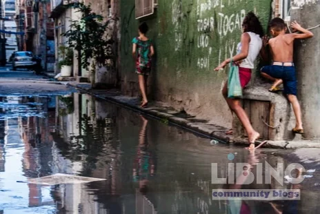
The Acari River in northern Rio de Janeiro has a history that reads like a ledger of social policy and climate risk. Once a source of childhood memories for Leticia Pinheiro and thousands of others, its waters have shifted from lifeblood to a sentinel of vulnerability. This article examines how climate change amplifies urban hazards in informal settlements, and how a memory-led approach could reframe accountability and investment in Rio’s favelas.
The stakes are not merely environmental. They are political, cultural, and logistical: without inclusive infrastructure and rights, memory becomes resistance, and resilience becomes displacement. The analysis below unfolds in four blocks, each designed to uncover a distinct layer of this dynamic—from data-driven insights to historical memory, to the causal chain of exposure, to practical reconstructions offered by researchers and community organizers.
We begin with a data-informed view of how climate risk operates in the Acari complex, then move to the contrasts between formal city planning and lived experience, followed by a causal mapping of how deforestation, garbage, and flood dynamics interact with housing and services. The final section translates memory work into actionable policy propositions and community-led responses. Throughout, the central thread remains: Favela climate memory is not nostalgia; it is a strategic asset for climate justice and urban reform.
Analytics perspective on Favela climate memory
The Acari River’s contemporary profile as a flooded, polluted open canal is the product of decades of policy decisions, topography, and poverty-driven settlement patterns. In the 1920s, the favela system solidified on swampy margins of the city, where precarious housing met unconsolidated land and limited municipal services. Flood events have always mattered here, but climate change has intensified both frequency and severity, turning once episodic shocks into chronic risk.
A data-driven reading of recent history shows a clear pattern: when tropical rains intensify, the Acari complex absorbs the overload first. A flood in January last year displaced as many as 20,000 residents across an area already strained by overcrowding, poor drainage, and substandard housing. The meteorological hotspot aligns with a regional drainage network ill-equipped to handle extreme precipitation, revealing a structural mismatch between community needs and municipal capacity.
The broader climate-urban system amplifies vulnerability through four channels:
- Exposure – Informal settlements sit on floodplains and hill slopes with inadequate waste management. The river washes through informal margins where containment structures are weak or absent.
- Sensitivity – Housing materials, floor elevations, and furniture retention strategies become visible indicators of resilience. Residents lift belongings to upper levels and reinforce interiors with brick or concrete to mitigate losses.
- Adaptive capacity – Memory-driven practices, such as community assemblies and disaster rehearsals, show how residents interpret risk and mobilize networks, even under resource constraints.
- Governance gap – The data point to a persistent misalignment between disaster risk management and the realities of informality, poverty, and gang-police safety dynamics.
The epidemiology of climate risk in these spaces is not only about episodic floods. It includes long-standing environmental hazards—pollution, poor sanitation, and deforestation—that magnify flood impacts and create compounding health risks. In the Rio context, memory becomes a dataset: the recollections of floods, relocation, and everyday adaptation form a qualitative layer that can sharpen quantitative insights when paired with housing quality metrics and service coverage statistics.
The Favela climate memory framework emerges as a synthesis of these strands. It posits that memory circles, led by residents and historians, can yield richer, more nuanced indicators of risk than conventional metrics alone. When these memory-based insights are integrated with city-wide data, they illuminate not only where danger resides but why it continues to persist. The aim is not nostalgic remembrance but a diagnostic tool for climate justice—one that binds data to legitimate action.
In this analytic frame, two propositions matter: first, that climate risk in the favelas is structurally embedded in land use and housing tenure; second, that memory-based documentation is a legitimate, powerful input for policy design. The evidence from Acari and similar settlements supports both propositions, showing that memory circles do more than preserve stories; they catalyze political legitimacy for public investment and rights-based upgrading.
Contrasts and comparisons
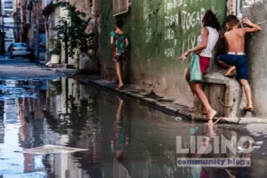
The narrative of the Acari River cannot be separated from the contrasting geographies of Rio de Janeiro. On one side lies the formal city, with its grand avenues, standardized housing, and centralized services. On the other side are the favelas, where access to clean water, sanitation, and education remains uneven and where floods feed a longer history of marginalization. The display in Favela Climate Memory makes the contrasts tangible: it juxtaposes the city’s promotional imagery with the lived realities of residents who watch the river rise, not as a scenic backdrop but as a threat to livelihoods, photographs, and family documents.
In formal neighborhoods, memory is often curated and archived by institutions with resources and influence. In the favelas, memory is carried by elders, youth groups, and memory circles that gather in makeshift spaces or community museums. The contrast is not merely about memory storage; it is about who has the authority to interpret the past and influence the future. The Maré Museum, for example, hosts a tangible reckoning—palafitas models, maps, and testimonies—that reframes the river as a historical force and a potential ally in planning.
This distinction has practical consequences. When planners and investors discuss climate adaptation, they often rely on formal indicators that ignore informal settlements’ experiential knowledge. The exhibition’s narrative insists that a climate strategy without memory-informed input risks repeating past inequities. The contrasts also reveal a political logic: authorities frequently framed relocation or beautification as progress, even while such policies tended to erase the social networks and historical ties that sustain favelas.
The contrast extends to environmental outcomes. In formal zones, the presence of integrated sanitation and regulated drainage reduces the probability that a single flood event will cascade into a multi-year disruption. In contrast, in areas like Acari, inadequate infrastructure converts rain into systemic risk, with water receding slowly and trash blocking channels, ensuring repeated vulnerabilities even after a flood recedes. The outcome is not simply a matter of weather; it is the product of governance choices, investment priorities, and the social contract that shapes who gets protected and who bears the costs.
Memory, in this frame, becomes a bridge across the contrast. It communicates why upgrading matters beyond aesthetics or asset protection. It translates a river’s volatility into a narrative of rights, and it anchors the political demand for durable, equitable infrastructure as a shared responsibility rather than a charity project.
Causes and effects chain
The city’s climate exposure in the Acari complex is the product of a cascade of interconnected causes. Understanding this chain clarifies where interventions can break the cycle and how memory-informed policy can break a pattern of recurrent losses.
First, historical deforestation and urban expansion around watercourses have destabilized natural drainage and increased surface runoff. The removal of mangroves, wetland buffers, and other natural barriers reduces the landscape’s capacity to absorb heavy rains. Second, wastewater and waste mismanagement clog channels and worsen flooding. When rainfall exceeds the designed capacity of the drainage network, floodwaters overrun homes on stilts and lower floors alike.
Third, housing informality compounds risk. The precarious construction of shacks and the lack of elevated foundations leave residents more vulnerable to water ingress and structural failures. Fourth, service gaps—irregular water supply, inconsistent sanitation, and limited waste collection—erode resilience and amplify post-disaster recovery times. Each factor does not act in isolation; their interaction creates a vulnerability amplifier that is particularly intense in the Acari complex.
The consequences are multifold. Material losses include furniture, documents, and family mementos, all of which become cheaper to replace in formal settings than reconstructing in a rivulet of mud and floodwater. Yet the non-material costs are equally severe: memory is eroded as photographs and records are destroyed or dispersed, erasing a community’s documented history and undermining its claim to space and resources.
The exhibition’s memory circles capture this dynamic in a way that standard disaster metrics cannot. They show how families adapt by elevating beds on brick bases, how youth leaders preserve local histories through palafita-replica storytelling, and how community museums curate a counter-narrative to the city’s gloss of progress. This is not mere nostalgia; it is a lived calculus of risk, reward, and the social value of collective memory as a determinant of future investment.
The causal chain suggests a critical policy intervention: prioritize upgrading informal settlements with flood-resilient design, land tenure security, and inclusive governance that centers memory-based data. The logic is straightforward—addressing the root causes of exposure and vulnerability reduces flood damages, protects social networks, and preserves cultural ecosystems that underpin resilience.
Expert reconstruction and memory work
The final block centers on reconstructive proposals informed by practitioners and researchers who have spent decades advocating for climate justice in Rio’s favelas. Theresa Williamson’s perspective anchors the discussion: memory is essential to solving the climate crisis because belonging engenders a sense of identity and responsibility for one’s territory. When residents know the soil, the trees, and the shared history, they care enough to defend and invest in their own neighborhoods.
Williamson’s Catalytic Communities and its Sustainable Favela Network have advanced a practical agenda that reframes upgrading as a right rather than a favor. The network’s approach blends formal policy instruments with grassroots innovation, recognizing that favelas are long-term communities with distinct social and cultural capital. The exhibition material—memory circles, oral histories, and community-led mapping—translates this stance into a usable political asset, one that can demand funding for infrastructure upgrades, better land-use planning, and resilient housing standards.
The reconstruction frame also incorporates the lived experiences of individuals like Leticia Pinheiro, whose family history in Acari anchors a broader claim for climate justice. The memory-driven narrative emphasizes that floods are not isolated events; they are the cumulative result of policy choices that undervalue informal settlements. As residents recount, successful adaptation will require more than isolated flood defenses; it will demand a holistic upgrade of public services, social protection, and governance legitimacy.
Practical policy directions emerge from this synthesis. They include:
- Rights-based upgrading — secure tenure for residents and formal recognition of informal housing as legitimate urban fabric.
- Integrated drainage and sanitation — invest in nature-based and engineered drainage solutions that reduce overflow, while expanding access to sanitation and clean water.
- Memory-informed planning — incorporate memory circles and community museums into urban planning processes, turning stories into data for risk assessment and resource allocation.
- Climate-justice finance — leverage municipal, state, and federal funds with conditions that ensure long-term maintenance and community governance.
- Urban greening and heat mitigation — address the urban heat island effect in dense favelas by planting trees, restoring mangroves nearby, and creating shaded public spaces.
The memory-centered approach is not a distraction from technical solutions; it is a way to ensure that engineering and budgeting reflect the needs, identities, and networks that keep communities resilient. In Rio’s climate reality, the most effective interventions blend engineering with cultural and political legitimacy. The exhibition and its memory circles demonstrate how memory can be a practical, action-oriented tool for climate justice, not a decorative archive.
In sum, Favela climate memory offers a framework for rethinking Rio’s urban future. It reframes vulnerability as a shared responsibility and resilience as a collective asset. The Acari River is not only a floodplain; it is a mirror that reflects who Rio is, who it intends to become, and who will be asked to bear the costs of the city’s climate ambitions. By elevating memory, policy, and people in unison, Rio can transform a history of marginalization into a blueprint for inclusive, sustainable growth.
A final reflection ties the four blocks together: climate justice requires a city that treats memory as infrastructure. Without it, data become dry lines on a map; with it, data become a public mandate for upgrading and rights enforcement. The Acari experience suggests that when communities are invited to map their own risk, to recount their histories, and to participate in decisions about the city’s future, climate adaptation becomes a project of shared sovereignty rather than a set of top-down adjustments. In this sense, Favela climate memory is not a peripheral narrative—it is a central governance strategy for a city that must adapt to a warming world.
Practical path to memory-informed upgrading
To address the practical shortfall in turning memory into measurable action, Rio can pursue a path that blends technical fixes with community governance. Memory circles become a living data source, linked to land tenure, drainage upgrades, and service delivery in a rights-based framework.
Table: Indicators of flood risk in Acari (illustrative)
| Indicator | Historic | Current |
|---|---|---|
| Flood frequency (per year) | ~0.3 | ~1.1 |
| Displaced households (last event) | N/A | ~20,000 |
| Waste channel blockages | Moderate | High |
| Sanitation access | ~60% | ~58% |
This snapshot shows how core risk signals shift over time when planning moves from static metrics to living community data.
Example scenario: In a 12-month pilot, memory circles co-create maps of flood routes, guiding a mixed nature-based and engineered drainage plan that reduces post-flood disruption by an estimated 40–50%.
Analytical synthesis: from memory to action
Memory circles inform project approvals, line-item budgets, and community-led monitoring dashboards. By pairing qualitative narratives with simple quantitative indicators, planners can set realistic targets for relocation, drainage upgrades, and service expansion that stay loyal to residents’ lived experiences.
Memory-informed planning steps
- Document memory circles and map risk zones with residents
- Co-design upgrade options: drainage, housing elevations, land tenure
- Run a small-scale pilot with clear governance rules
- Monitor outcomes with shared dashboards
In practice, this approach aligns engineering with social legitimacy, turning memory into an asset for climate justice and urban reform.
What is Favela climate memory and why does it matter for Rio?
Memory of floods, relocation, and daily adaptation provides a qualitative layer that explains how and why current risks persist. It connects residents’ lived experience to policy choices, guiding upgrades that protect livelihoods and preserve social networks. This perspective helps ensure that investments address both infrastructure and rights, yielding durable resilience for informally housed communities.
Analytically, memory acts as a bridge between data and legitimacy, improving planning credibility and equity outcomes by incorporating community voices into risk assessment and budgeting.
How does memory-informed planning improve flood resilience in Acari?
It couples residents’ local knowledge with practical actions like upgraded drainage and land tenure security. This synergy reduces vulnerability by aligning physical design with social organization. A memory-informed plan prioritizes pathways of protection, ensuring upgrades serve everyday life and not just formal spaces.
In practice, pilots co-created with communities help test drainage layouts, early warning cues, and maintenance regimes, producing actionable lessons for scale-up.
What are memory circles and how do they function in planning?
Memory circles are community gatherings that document experiences, maps, and histories related to environmental risk. They translate stories into data points, informing risk maps, venue choices for interventions, and governance structures. They create a shared knowledge base that planners and residents use to co-design upgrades and monitor progress.
As a governance tool, they foster legitimacy and sustained participation beyond one-off projects.
What policy actions support rights-based upgrading?
Policy actions include secure tenure for residents, recognition of informal housing as part of the urban fabric, integrated drainage and sanitation plans, and governance mechanisms that require ongoing community oversight. These steps ensure upgrades are durable, inclusive, and correctly funded.
Practically, this means binding agreements, transparent budgets, and co-managed maintenance programs that endure beyond political cycles.
How is climate-justice finance secured for favelas?
Finance mechanisms link municipal, state, and federal funds with conditions that require evaluation by memory circles and community monitors. Resulting grants or loans are tied to performance metrics such as reduced displacement and improved service access, with long-term maintenance funded through shared governance models.
Transparent disbursement and clear accountability are central to sustaining this funding over time.
How can residents participate in the planning process?
Residents participate through memory circles, community museums, participatory mapping, and representation in planning councils. This involvement ensures plans reflect local priorities and creates a responsive feedback loop that corrects course as conditions change.
Structured participation builds trust and strengthens the social contract, making climate adaptation a shared project.




Add a comment
To comment, you need to register and authorize
Comments