

Table of contents
Lead
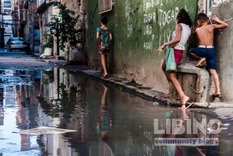
Rio de Janeiro's Acari River was once a lifeline for families who fished, bathed, and built livelihoods along its muddy margins, weaving daily life with the river's rhythms. Today residents call it a valão, an open canal for sewage and rubbish, a stark symbol of how climate risk compounds urban exclusion in northern Rio. Extreme rainfall now triggers floods that invade homes and arrears infrastructure, forcing families to live on upper floors and spend scarce resources on makeshift protections. Favela Climate Memory, expressed through a community museum exhibit, reframes disaster as a long-term injustice and points to memory-based pathways for climate justice, public investment, and urban renewal.
Analytics Perspective
The Acari case is not an isolated incident but a lens on how climate risk operates where informality and poverty intersect. Favela Climate Memory emerges as a methodological instrument that turns memory into data for risk reduction and policy advocacy, not mere nostalgia. In this frame, climate risk in informal settlements becomes analyzable through historical memory, housing quality, and access to services, revealing patterns that static statistics often miss. The analysis also illuminates how memory circuits translate into collective resilience, bridging lived experience with municipal planning. This fusion of memory and data challenges conventional climate policy to account for urban climates and social realities simultaneously.
In January last year, the Acari complex was hit by an unprecedented flood that invaded the homes of 20,000 people, a stark demonstration of how extreme weather compounds vulnerability in informal settlements. The flood was not an isolated event but a consequence of a long history of inadequate infrastructure and neglected neighborhoods. The pattern is clear: when rainfall spikes, the most precarious housing stock bears the brunt, and the social and environmental costs accumulate across generations. The analysis here tracks those costs and translates them into policy-relevant insights for climate justice in Rio.
Key indicators anchor the analysis: the environment, housing, and governance shape risk exposure. The 1966 flood—the so‑called flood of the century—and the following year’s disaster left hundreds dead and about 50,000 homeless, underscoring a recurrent vulnerability that policy has failed to interrupt. The 2022 Brazilian census shows public services exist in favelas but at uneven quality: roughly 84% have a water supply and about 75% have some form of sanitation, signaling partial, not universal, coverage. These figures matter because access to reliable water and sanitation reduces flood‑related hazards and waterborne disease during emergencies.
From a global vantage, informal settlements house roughly a quarter of urban inhabitants and are projected to reach 3 billion people by 2050. In Rio, the favelas account for a sizable share of the population; their persistence is a structural feature of the city rather than a temporary condition. These realities push climate justice beyond environmental management into the realm of social rights, where memory becomes a form of data about equity, access, and opportunity. The analytical value of Favela Climate Memory lies in showing how memory can illuminate the pathways through which climate risk is experienced, narrated, and ultimately mitigated.
Theresa Williamson, a Rio-based planner who has spent decades engaging with favelas, insists that memory is essential to climate action because belonging fosters care for the environment. When people know their soil, trees, and shared histories, they develop a stronger commitment to protect their place. This insight is not nostalgic; it underpins practical strategies for climate resilience within informal settlements and argues for infrastructure guarantees as a matter of rights rather than charity. The analysis therefore treats memory as a legitimate source of expertise, shaping governance that honors both history and future needs.
Contrast with formal policy and urban development
The exhibition frames a fundamental contrast: the city’s formal development has repeatedly relied on the labor and housing of the poor without delivering durable living conditions. The phrase Neglect is policy, spoken by community leaders, captures the institutional reluctance to invest in upgrades that would stabilize living conditions and reduce climate risk. This attitude manifests in relocation schemes that decouple residents from their origins and create new forms of vulnerability, such as longer commutes, fragmented social networks, and fragile housing replacements.
To compare scenarios, consider two pathways: upgrade and integration versus displacement and marginalization. The first envisions formal infrastructure upgrades, formal land tenure, and inclusive service delivery that protect residents during floods and reduce heat stress. The second relies on temporary fixes or selective improvements that preserve a city image for visitors while leaving basic housing and sanitation needs unmet. The exhibit argues that the post‑disaster narrative often serves the latter, while memory circles reveal a different, more durable logic: communities resist erasure by insisting on rights, not favors.
The memory-based approach also reframes climate adaptation as a cultural project, linking festivals, dances, and local knowledge to ecological stewardship. It demonstrates how the favelas have historically contributed to Rio’s identity—carnival, informality, and the passinho dance—while advocating for infrastructure that respects this heritage rather than erasing it. The exhibit’s framing thus links cultural resilience to climate resilience, a synergy often overlooked by standard urban planning.
Cause and Effect: Web of risk and memory
The climate risk faced by Acari and surrounding favelas arises from a cascade of interacting factors, not a single failure. Deforestation on hilltops reduces rainfall infiltration and increases surface runoff, amplifying flood peaks in low-lying areas. Poor waste management and limited sanitation concentrate contaminants in waterways, worsening health outcomes during floods and heightening long‑term environmental degradation. These conditions are intensified by overcrowding and informal housing on hillside slopes, which expose residents to landslide risk and hinder rapid evacuation.
A second layer links urban growth to governance gaps. The expansion of informal settlements near the bay and along river margins has outpaced formal service provision, creating structural vulnerabilities that recur with each new rainfall event. The memory circles in the exhibition document how relocation programs and new settlements establish a pattern: communities adapt by building higher floors and stronger bases, but these adaptations are costly and precarious, delaying long‑term safety and resilience. In this context, memory becomes a map of where failures happened and where they are likely to happen again.
More broadly, the link between climate change and social inequality becomes visible through this lens. Global projections show urban climate risk rising as cities grow, with informal settlements bearing a disproportionate share of heat, flood, and pollution exposure. The framing here uses climate justice as the organizing principle: unless policy explicitly addresses the rights and needs of the poor, resilience remains partial and uneven. Memory data therefore functions as a corrective, offering a counter‑nactual to the erasure of lived experience in environmental policy debates.
Expert reconstruction: memory as a resource for climate justice
Catalytic Communities, the organization behind the Sustainable Favela Network, positions memory as a credible foundation for climate justice. The network brings together voices from more than 300 favelas, turning distinct experiences into a shared agenda for infrastructure upgrades, land tenure, and water and sanitation improvements. This collective approach recognizes favelas as enduring communities that generate culture and knowledge, not temporary settlements awaiting clearance.
The Maré Museum, born from community collaboration and local memory circles, offers a tangible site where residents reframe history through palafitas replicas, archival photos, and testimonies. The project demonstrates how museums can function as living laboratories for climate adaptation—capturing data, inspiring action, and legitimizing residents’ claims to space and services. Memory, in this sense, becomes a practical resource rather than a nostalgic souvenir of hardship.
Memory tools also translate into concrete environmental actions. For example, grassroots efforts to plant trees and restore urban green cover in Antares and surrounding Santa Cruz neighborhoods reduce ambient temperatures and improve stormwater absorption. After relocation experiences, residents advocate for greener urban renewal that integrates new housing with shade, water retention, and accessible sanitation. These initiatives show how expert and community knowledge co‑produce resilient urban futures grounded in rights and identity.
Final reflections
Favela Climate Memory reframes the climate crisis as a social justice project embedded in everyday life, not merely in technical blueprints or rainfall statistics. By linking memory to policy, the exhibition makes visible the costs of neglect and the potential gains from inclusive investment. The approach asserts that upgrading informal settlements is not charity but a matter of rights, security, and dignity for millions of city residents. In Rio and beyond, memory becomes a strategic resource for shaping climate‑just urban futures.
Practical pathways for climate justice in Rio
Memory informs risk; translating memory into durable upgrades requires concrete pathways across governance, finance, and design. The following concise options show how Rio can scale up improvements while protecting residents' rights.
Illustrative upgrade options are summarized in the table below.
| Pathway | Key Actions | Expected Benefit | Estimated Cost | Timeframe |
|---|---|---|---|---|
| Green canopy expansion and shade networks | Plant 300–400 trees; create shaded pedestrian routes | Reduces surface heat; lowers thermal stress on residents | Moderate | 3–5 years |
| Permeable pavements and rain gardens | Install permeable surfaces; create bioswales | Reduces flood peaks and improves water quality | Moderate | 2–4 years |
| Water and sanitation connections expansion | Extend network reach; upgrade informal service points | Improved health; reduced waterborne risks | High | 2–3 years |
| Elevated walkways and flood-safe access | Raise key paths; create evacuation routes | Safer mobility; faster evacuations | Medium–High | 1–2 years |
| Formalization and service integration | Secure land tenure; integrate with formal services | Stability; long-term maintenance | Medium | 3–5 years |
Analysis: A balanced mix of nature-based and infrastructure measures, paired with formal rights, can reduce risk while strengthening community governance. Financing through participatory budgeting and cross-sector partnerships is essential for scale.
Illustrative snapshot of potential benefits In targeted blocks, a coordinated package can yield notable gains: heat relief through shade, flood peak reductions via green hydrological design, and healthier living conditions through better water access. This demonstrates how memory-informed planning translates into tangible improvements.
Community-led upgrade steps ensure residents guide design, implementation, and monitoring, securing lasting benefits beyond single projects.
- Co-design with residents and local NGOs
- Establish local planning committees
- Incorporate memory circles into design reviews
- Secure land tenure and formal service rights
- Pilot in two blocks with community monitors
- Scale through participatory budgeting
- Ongoing monitoring and maintenance with transparent reporting
Analysis: Ownership and governance emerge as critical drivers of durable resilience, ensuring upgrades are maintained and culturally aligned with local needs.
By aligning memory with concrete upgrades and rights-based financing, the city can advance climate justice for Rio’s favelas while preserving cultural identity and social cohesion.
What is Favela Climate Memory and why is it important for climate justice in Rio?
Favela Climate Memory is a community-centered approach that documents past climate impacts and present vulnerabilities to guide durable improvements, and it matters because it ties rights, memory, and planning into a single evidence-driven path for justice. It treats residents' histories as essential input for design, ensuring upgrades reflect lived experiences and local priorities. This approach makes policy more legible to communities and strengthens advocacy for service guarantees, land tenure, and equitable investment.
Memory becomes a usable form of knowledge, guiding risk assessment, prioritization, and accountability. It connects daily life with structural change, turning stories into a policy compass rather than a peripheral narrative. In this way, memory supports more inclusive, rights-based climate action that benefits long-neglected neighborhoods.
How does memory-based data inform climate policy for informal settlements?
Memory-based data translates lived experiences into actionable indicators that static statistics often overlook. It highlights where services fail, where infrastructure is most vulnerable, and how households adapt technologies and practices. This makes policy targets more precise, grounded in local realities, and easier to monitor. In practice, it guides where to invest first, how to design inclusive processes, and how to measure success through community-defined outcomes.
Analytically, this approach links housing quality, service access, and historical exposure to risk, creating a more complete picture of resilience needs. It also fosters accountability by making residents part of the data-generating process.
What concrete upgrades are recommended for Acari and surrounding favelas?
Upgrades span five main areas: green infrastructure, water and sanitation expansion, drainage and flood mitigation, safe mobility, and governance. Concrete steps include planting shade trees, installing permeable surfaces, extending water connections, building elevated walkways, and formalizing land tenure. These actions reduce heat exposure, cut flood risk, improve health outcomes, and stabilize communities through rights-based improvements. Implementations should be co-designed with residents and funded via participatory budgeting and multi-stakeholder partnerships.
In practice, pilots in a few blocks can demonstrate effectiveness before scaling citywide, ensuring legitimacy and learning from community feedback.
How can communities participate in urban renewal without displacement?
Active participation is essential. Communities should co-design plans, retain housing tenure, and access affordable, quality municipal services. Transparent planning meetings, neighborhood assemblies, and local monitors help ensure that upgrades do not erode social networks or push residents out. Participatory budgeting, community land trusts, and clearly defined rules against forced relocation are practical tools. By tying renewal to rights and protections, residents gain a stake in the process and in the long-term success of projects.
Monitoring and grievance mechanisms provide voices for ongoing adjustment, keeping renewal aligned with community needs rather than external agendas.
What roles do green infrastructure and water services play in resilience?
Green infrastructure lowers urban temperatures and improves stormwater management, while reliable water and sanitation services reduce disease risk during floods. Together, they create a cooler, healthier, and more predictable urban environment. In informal settlements, these measures must be designed with tenants’ rights in mind and implemented with community oversight to ensure maintenance and affordability. The combined effect is a more resilient neighborhood that can withstand extreme rainfall and heat waves without displacing residents.
How is progress measured in climate justice projects?
Progress is measured through a mix of access indicators (water and sanitation coverage), risk indicators (flood frequency, heat exposure), governance metrics (land tenure security, inclusive budgeting), and resident-reported well-being. Regular, community-led audits, transparent budgets, and open data platforms are essential. By tracking both physical outcomes and social impacts, policymakers can adjust strategies quickly and demonstrably demonstrate gains in equity and resilience.




Add a comment
To comment, you need to register and authorize
Comments