

Lead
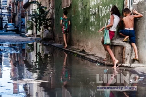
The Acari River is more than water in a city-changing story. For decades, floods shaped the daily life of the Acari favela and the surrounding Maré complex. Today, heavier rains arrive with greater intensity, and the river is increasingly blamed for the climate disasters that cripple homes and livelihoods. This article uses a climate-justice lens to examine how memory, policy choices, and local action intersect in Rio’s favelas, where the line between hazard and identity runs through water and soil. It centers the lived experience of residents while situating their memories within a larger urban governance debate about upgrading informal settlements. This is climate justice in Rio's favelas: a fight over memory, infrastructure, and the right to a livable city.
Leticia Pinheiro, 28, grew up hearing stories about the Acari River. She recalls a time when the river’s clean waters fed a community where families fished, bathed, and found opportunity along its banks. Now that same water is treated as the culprit behind increasing floods and displacement. The shift illustrates a broader question: when climate risks rise, who gets to make decisions about who stays, who adapts, and who leaves? This article follows the thread from river to residence, from memory circles to policy debates, and from a public exhibition to the streets where residents plan for the next storm.
The stakes are real. A January flood last year inundated the homes of 20,000 people across the Acari complex, while residents learned to live on higher floors and reinforce bed bases with brick and concrete. The memory of loss is not a relic; it informs today’s relocation fears and tomorrow’s adaptation strategies. The exhibition Favela Climate Memory compiles testimonies and data from ten favelas, underscoring that climate justice hinges on preserving households, histories, and housing that can withstand shocks rather than erasing them from the map.
Through analytics
Analytical framing reveals how climate risk in Rio’s favelas is inseparable from social and political history. The Acari River’s transformation from a local watercourse into a flood-prone channel mirrors a city’s failed infrastructure and decades of unequal investment. In this analytics block, we synthesize memory with metrics to show what the data really mean for climate justice in Rio's favelas.
First, the geography matters. Acari sits near the Acari favela on swampy terrain in northern Rio de Janeiro, an area historically shaped by migration, informal housing, and precarious sanitation. When tropical rains surge, the entire Acari complex bears the impact. The January flood that displaced tens of thousands illustrates a pattern: floods are not singular events but outcomes of coupled vulnerabilities—overcrowding, deficient drainage, and limited access to affordable, climate-resilient housing. This is not only a hydrological problem but a governance one, where risk is redistributed rather than reduced.
Second, the scale of exposure is widening. The 2022 census data from the Brazilian Institute of Geography and Statistics (IGBE) show that a majority of favelas have some form of water supply (about 84%) and sanitation (around 75%), yet these services do not translate into resilience against flood risk. The data distill a core paradox: formal utilities exist, but the spatial and temporal patterns of vulnerability persist. The urban poor remain disproportionately exposed to environmental hazards, despite appearing integrated into the city’s service network. This paradox lies at the heart of climate justice in Rio's favelas.
Third, memory as data. The Favela Climate Memory project collects voices from more than 400 people in conversation circles, bridging subjective memories with historical data. This synthesis reveals how climate risk is learned, adapted, and resisted within communities. The data do not just recount floods; they map how residents understand cause and consequence, how memories shape present decisions, and how policymakers can translate remembrance into durable protections. In short, memory is a usable dataset for resilience planning rather than a nostalgic remnant of a lost era. This is climate justice through a data-informed lens, not a sentimental account of hardship.
Through contrast
The contrasts in this story are not merely descriptive; they reveal how power, perception, and planning shape outcomes. The Acari River embodies a dual reality: it is a cradle of social memory and a corridor of risk. Where a few decades ago residents watched a relatively clean river sustain daily life, today many call it a valão—a channel for sewage and rubbish. The exhibition and community voices juxtapose a past where water meant nourishment with a present where water signals threat. This contrast is essential to understanding climate justice in Rio's favelas.
On one side stands a city that built a nation on the backs of the working poor. Acari’s growth followed Avenida Brasil’s construction in the 1940s, with slums and favelas clustering on hilltops and river edges. The city’s development model rewarded the access to employment while neglecting housing quality, drainage, and service delivery. On the other side are residents who have remade their environments out of necessity: building homes on higher ground, using bricks and concrete to elevate furniture, growing trees in public spaces to moderate heat, and coordinating memory circles to document losses and strategies. The contrast raises a crucial question: what does an upgraded city look like when upgrading means not just expanding service networks but reconfiguring risk so that it no longer concentrates in the same neighborhoods?
Expert Theresa Williamson, a Rio-based planner, argues that favelas are not temporary slums but persistent, culturally central communities. The contrast intensifies when political incentives encourage “beautiful city” narratives that hide poverty. The memory circles in Maré and Acari reveal a counter-narrative: upgrading must be rights-based, inclusive, and long-term. The contrast is not merely about aesthetics; it concerns who is visible in city-building and who bears the costs of climate risk without due process or compensation. These tensions are central to the future of climate justice in Rio's favelas.
Through cause-and-effect relationships
Cause-and-effect analysis exposes the chain from governance choices to lived vulnerability. A history of neglect, informal housing, and insufficient infrastructure creates a fragile ground for climate shocks. When authorities relocate families—such as the Antares experience in Santa Cruz—the consequences extend beyond distance. Families trade one hazard for another: new neighborhoods with different exposure profiles, longer commutes, and altered social networks that erode informal safety nets. The result is a reinforcement of risk rather than a reduction of it, a pattern seen across informal settlements in Rio.
The cause-and-effect chain begins with policy signals and ends with a lived crisis. Policies that labeled favelas as marginal, then justified relocation or “improvement” projects without genuine consultation, produced a two-tier effect: the built form changed, but the underlying drivers of vulnerability—crowding, poor drainage, pollution, and limited access to continuous services—remained unaddressed. When floods arrive, memories of displacement compound the trauma: households lose documents, photographs, and family histories. The memory circles show that disasters are not just environmental events; they are social processes that rewrite community identity and continuity. This is why climate justice requires not only stronger drainage or housing upgrades but a deliberate approach to past harms and future protection.
Deforestation and mangrove clearance accompany the growth of favelas, intensifying heat and reducing natural buffers. The Santa Cruz example demonstrates a feedback loop: as wooded areas give way to housing, microclimates intensify heat, while deforestation erodes channels for stormwater. The result is a cycle where climate risk accelerates, and residents’ adaptive strategies—building higher floors, storing valuables on upper levels, and shifting livelihoods—become routine rather than exceptional. Understanding these causal chains helps explain why conventional urban planning often falls short for favelas and why climate justice requires rethinking risk allocation, asset protection, and social rights.
Through expert reconstruction
Experts offer a reconstructive view that blends memory, data, and policy reform. Theresa Williamson argues that memory is essential to solving the climate crisis because belonging creates identity and commitment to a place. In her view, memory makes the case for upgrading favelas as permanent, integrated communities rather than temporarily tolerated settlements. The Favela Climate Memory project embodies this approach by translating personal histories into political leverage for infrastructure guarantees and basic rights.
Leticia Pinheiro emphasizes that memory is not nostalgia but a living archive necessary for resilience. Her observation that climate change now threatens not only homes but photographs, documents, and family legacies reframes adaptation as preservation. The exhibition’s storytelling becomes a potential blueprint for inclusive planning: connect urban services to the realities of informal settlements, ensure that upgrades protect cultural and material memory, and recognize the community’s own governance structures as valuable partners in adaptation.
Practically, reconstruction requires four intertwined actions:
- Guarantee basic infrastructure rights: reliable water, sanitation, drainage, and energy access designed for informal settlements.
- Integrate upgrading with preservation of social networks and memory institutions, such as community museums and memory circles.
- Adopt participatory governance that gives communities a decisive say in relocation and service delivery, with transparent, rights-based criteria for any displacement.
- Incorporate nature-based solutions and urban greening to moderate heat, reduce flood risk, and create green corridors that align with residents’ needs and memories.
In this reconstruction, the Acari case becomes a model for climate justice in urban South America: a framework that links technical resilience with cultural continuity, recognizes the city’s informal fabric as a source of strength, and uses memory as a compass for policy design. The exhibition’s memory circles illustrate how communities can co-create knowledge, mobilize political will, and attract broader investment by narrating their climate reality with data-backed evidence and a clear demand for rights-based upgrades.
Conclusion
The Acari River story is not merely about floods or a single neighborhood; it is a lens on climate justice in Rio’s favelas. Memory, data, and community leadership together form a stronger claim for durable, inclusive solutions that protect both people and history. As the city and the region face rising temperatures and more extreme storms, climate justice in Rio's favelas will depend on turning memory into policy, upgrading without erasing, and ensuring that the most vulnerable residents are central to every planning decision.
Note: The figures cited reflect documented events and census data within the Rio de Janeiro metropolitan area and are used here to illustrate the broader dynamics of climate risk, memory, and urban governance in informal settlements.
Through actionable upgrading
Upgrading must translate memory into durable rights and physical protections. The following concise plan ties community governance to tangible improvements, ensuring climate resilience without erasing local histories.
First, a practical data table converts lived experience into concrete actions, disciplined by timelines and funding. This supports equitable planning that prioritizes informal settlements as permanent, integral parts of the city.
| Action | Lead Actor | Timeframe | Funding | Indicator |
|---|---|---|---|---|
| Baseline spatial mapping of flooding, drainage and housing | Community councils + researchers | 0–12 months | Municipal funds + grants | Digital map available to residents |
| Co-design workshops for housing upgrades | Residents Council | 6–12 months | Grants + NGO support | 5 community plans finalized |
| Drainage upgrades and flood-proofing | City engineers + residents | 12–36 months | Public funds | Flood depth reduced >30% |
| Green corridors and shade trees | Parks/Urban forestry | 24–60 months | Climate funds | Heat index declines by several degrees |
These actions connect memory to material change, ensuring upgrades reduce risk while keeping cultural identity intact. The approach emphasizes accessibility, non-displacement, and long-term service continuity as core indicators of success.
Analysis: The table translates intangible memory into tracked performance, turning rights-based upgrading into a visible, accountable program for climate resilience in informal settlements. It anchors investments in residents’ daily realities and strengthens trust with transparent criteria.
Memory circles and planning forums provide the data backbone for this progress, turning shared stories into a corporate-like dashboard that residents can read and trust.
- Rights-based relocation criteria with explicit safeguards.
- Prioritized flooding zones for early upgrades.
- Nature-based cooling and water-sensitive design embedded in housing projects.
In short, upgrading must be inclusive, data-informed, and anchored in community governance to sustain climate resilience in Rio’s favelas.
---
What does climate justice mean for Acari and Rio’s favelas?
Climate justice means protecting homes, memories, and rights, not just reducing temperatures or flood depths. It requires upgrading that keeps residents in place, maintains social networks, and guarantees access to essential services. In practice, this translates to non-displacing projects, community-led planning, and accountability for investment. The result is a livable city where memory and culture are part of the response to climate risk, not casualties of it.
This lens helps ensure that resilience is people-centered, accessible, and sustainable, rather than a one-time infrastructure fix.
How can memory circles influence upgrading decisions?
Memory circles turn personal histories into policy signals. They document losses, identify recurring risks, and validate community priorities. When planners see memory as a usable dataset, they design relocations, services, and upgrades that honor attachments to place. This fosters trust, improves participation, and yields more durable solutions that reflect local needs and values.
In Rio, such forums have already helped shape rights-based upgrades and strengthen community governance around service delivery.
What concrete infrastructure upgrades reduce flood risk in favelas?
Key upgrades include reliable drainage networks, raised housing foundations, flood barriers where appropriate, and sealed access pathways that prevent blockages. Pairing these with nature-based approaches—green corridors, tree belts, and permeable surfaces—improves water absorption and reduces heat. Importantly, upgrades must be designed with residents’ inputs to ensure usability and long-term maintenance.
Measured improvements come from lower flood depths, fewer weeks of displacement, and more predictable access to utilities during storms.
Who funds upgrading projects in informal settlements?
Funding typically blends municipal budgets with state climate funds, national development grants, and concessional loans. Grants for community-led planning and capacity-building are crucial, as they empower residents to manage projects and maintain assets over time. Transparent procurement and co-financing commitments from multiple sources reduce the risk of incomplete upgrades.
Blended finance enables scalable, rights-based upgrades that stay aligned with residents’ needs and memory commitments.
How are residents involved in relocation decisions?
Residents participate through community councils and memory circles, with clearly defined criteria for relocation that prioritize safety, livelihood continuity, and access to essential services. Displacement must be a last resort, timed to minimize disruption to schooling and work, and paired with robust protections such as home replacement options and rent support. Transparency and ongoing feedback loops sustain legitimacy and trust in the process.
The goal is to reframe relocation from a forced outcome to a negotiated, rights-centered step in upgrading plans.





Add a comment
To comment, you need to register and authorize
Comments